Thursday, July 12, 2012

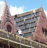
Westfield's Municipal Building Gets a Facelift

state_normal_school_04
A century and a score since its dedication as a State Normal School on June 21, 1892, the building that has housed the city of Westfield's Municipal offices from the late 1950s on is getting a well-deserved facelift. Scaffolding has wrapped the tired edifice in its promising embrace, anon dismantled to reveal a relic's rejuvenated skin, a face for the future. 'Tis a welcome sight, a work site worthy of the first Westfield structure to be listed on the National Register of Historic Places, that distinctive date occurring on March 8, 1978.


state_normal_school_westfield

Built at a cost of $150,000 to replace the old facility on Washington Street, the Commonwealth stretched about six and a half decades out of its investment before cramped and thoroughly antiquated quarters ("archaic" according to the eyes of Massachusetts Governor Paul A. Dever in 1951, on campus to speak at the June 23rd commencement ceremony) forced the decision and drive to move onto bigger and better things, an educational expansion that would one day transform a city wood known as Juniper Park into today's bustling and still-growing Westfield State University. An exchange of one dollar from Commonwealth to city secured the original 26 acre Western Avenue site of horse trails and shady glens and likewise a dollar from city to Commonwealth facilitated the purchase of the 59 Court Street structure, the agreement stipulating the building to be utilized "for municipal purposes only." Chapman Water Proofing, Inc. of Boston has been contracted to perform the current renovations at a cost of $3,400,000, a sum which would have allowed the building to be replicated another twenty times in 1892.


state_normal_training_school_02

Granite, brick and brownstone under the cover of a slate-tiled roof, the Romanesque design - the work of Boston firm Hartwell and Richardson, established 1881 - is reminiscent of renowned architect Henry H. Richardson's style, but the two interests are indeed, separate. Although neither gained the stature of H. H. Richardson in northeastern architectural circles, many of Henry W. Walker and William C. Richardson's (and later, third partner James Driver) structural accomplishments have made their way into the National Register of Historic Places, including the town hall in Ware, Massachusetts. A local example of Henry H. Richardson's work is the old Hampden County Courthouse on State Street in Springfield.


westfield_municipal_building_03

Postmarked in wintertime Westfield of 1921 and mailed for a penny, the handsome building of higher learning - in a postcard frozen - had by then hosted nearly thirty years of students, matriculating and moving on through its double front archways, the fits and starts of a dawning age of excitement in education anchored by the stalwart's granite foundation whilst soaring peaks overhead encouraged opening minds to move above and ever beyond. Today, the edifice is Westfield's municipal anchor, a tether to the community, a well-known face passed on Court Street, finally getting a makeover.

As always, thanks for stopping by and take care.


Related links:

Postcards: Court Street, Westfield, Massachusetts ~ http://explorewmass.blogspot.com/2009/03/postcards-court-street-westfield.html

Photos: Time and Water Flow, Springfield, Massachusetts, 1905 - 1920 ~ http://explorewmass.blogspot.com/2007/12/photos-time-and-water-flow-springfield.html

City of Westfield, Massachusetts ~ http://www.cityofwestfield.org/

MassLive.com article, June 6, 2012, "Westfield launches school and municipal building upgrades" ~ http://www.masslive.com/news/index.ssf/2012/06/westfield_launches_school_and.html

Triennial 1839 - 1907, State Normal School, Westfield, Massachusetts ~ http://www.hampdencountyhistory.com/westfield/wn/toc.html

Map: Bird's-eye View of Westfield, Massachusetts, 1875 ~ http://explorewmass.blogspot.com/2009/03/map-1875-birds-eye-of-westfield.html

Getting there, via Google maps: http://goo.gl/maps/8dmH


Home|Welcome|Table of Contents|Explore|Upcoming Events|Patrons|Marketplace|Contact|Privacy


Monday, June 25, 2012

Map of Massachusetts Public Libraries, c1914

According to this map, in 1914 all but one of 35 cities and 319 towns in Massachusetts were home to a free public library, a testament to the value assigned higher learning in the Commonwealth. There were 6,291,811 books ready to be read, with over a million volumes in the Boston public library alone.


Studying the pen and ink drawing by artist and educator George Hartnell Bartlett, (1838-1923), one is struck by the respect given each individual edifice, the love of subject mapped in lines, from Orleans to Williams- town, every library rating equal illustrative justice. Outside of the cities, we find simple structures still splendid, bestowed per Bartlett's pen with a level of dignity befitting any treasury of books, home or away, large or small. Additional examples of Bartlett's work and hints at his thought process can be found in his 1903 book, "Pen and Ink Drawing".


Bartlett has decided to draw both the old Springfield library and the new Springfield library into his map, and there is some truth to that image. Before the new city library was built, room had to be made, so the old library was moved back from State Street a distance, and for a short time, Springfield had two libraries at the Quadrangle.

There is a great article about the big move over at Springfield-History.com. Here's a link: http://www.springfield-history.com/moving-library. And here's a link to an earlier EWM post with photographs of Springfield's State Street, including the old library, prior to 1905: http://explorewmass.blogspot.com/2007/08/photos-state-street-springfield.html.

As always, thanks for stopping by and take care.


Map source: Library of Congress, Prints and Photographs Division, Published by George H. Bartlett, Pleasant St., Arlington, Mass., c1904/1915, Reproduction Number: LC-DIG-ppmsca-15909, http://www.loc.gov/pictures/item/2007681339/


More maps on EWM: Trails, Rails & Roads: Western Mass. Maps


Home|Welcome|Table of Contents|Explore|Upcoming Events|Patrons|Marketplace|Contact|Privacy


Friday, June 22, 2012

Independence Day Celebrations in Western Massachusetts

The summer skies of June and July will soon be bathed in brilliant blossoms of color and sound as Western Massachusetts celebrates the spirit of 1776 once again with fireworks and festivities galore. Here's a sampling of some of the pyrotechnic displays towns and cities are planning for this season of independence in the year 2012. While most of the following events are free, some do request a donation and others charge an entry fee. It's best to visit the applicable websites to get the scoop on all of the details of each venue (as well as any additional planned holiday happenings the town or city may offer, such as parades or concerts) before heading out.


Brimfield
Saturday ~ June 23
139 Old Palmer Road
Brimfield, Massachusetts
Directions to Old Palmer Road


Easthampton
Saturday ~ June 23 ~ 9:30 p.m. (Rain date: June 24)
Galbraith & Daley Fields
Easthampton, Massachusetts
Directions to Daley Field
More info: http://www.easthamptonspirit.com/


Monson
Saturday ~ June 23 ~ 9:15 p.m. (Rain date: June 24)
Monson High & Quarry Hill School
Monson, Massachusetts
Directions to Monson High School
More info: http://www.monsonsummerfestinc.com/events.htm


Northampton
Saturday ~ June 23 ~ 9:15 p.m. (Rain date: June 24)
Look Park
300 North Main Street
Florence, Massachusetts
Directions to Look Park
More info: http://www.northamptonfamilyfourth.com/


Holyoke
Friday ~ June 29 ~ Dusk (Rain date: June 30)
Holyoke Community College
Homestead Avenue
Holyoke, Massachusetts
Directions to HCC
More info: https://www.facebook.com/HolyokeCommunityCollege


Chicopee
Saturday ~ June 30 ~ 9:30 p.m. (Rain date: July 1)
Szot Park
Front Street
Chicopee, Massachusetts
Directions to Szot Park
More info: http://www.festofall.com/


Lenox
June 30 ~ 9:30 p.m.
Elm Court Estate
Lenox, Massachusetts
Directions to Elm Court Estate


Ware
Saturday ~ June 30 ~ 9:30 p.m. (Rain date: July 1)
Grenville Park
Walter Drive
Ware, Massachusetts
Directions to Grenville Park
More info: http://www.townofware.com/Pages/WareMA_MeetingCal/S037ECD82-037ECE06?formid=161


Westfield
Saturday ~ June 30 (Rain date: July 1)
Stanley Park
400 Western Avenue
Westfield, Massachusetts
Directions to Stanley Park
More info: http://www.stanleypark.org/page/fireworks-freedom and http://www.cityofwestfield.org/wp-content/uploads/2012/06/Community-Celebrations.pdf


East Longmeadow
Tuesday ~ July 3 ~ 9:00 p.m.
East Longmeadow High School
East Longmeadow, Massachusetts
Directions to ELHS
More info: http://www.eastlongmeadowma.gov/


South Hadley
Tuesday ~ July 3 ~ 9:15 p.m. (Rain date: July 5)
Michael E. Smith Middle School
100 Mosier Street
South Hadley, Massachusetts
Directions to MSMS
More info: http://www.southhadley.org/Pages/SouthHadleyMA_Recreation/specialevents


Sturbridge
Tuesday ~ July 3 ~ Dusk (Rain date: July 4)
Old Sturbridge Village
1 Old Sturbridge Village Road
Sturbridge, Massachusetts
1-800-733-1830
Directions to Old Sturbridge Village
More info: http://www.osv.org/orders/listprograms.html?ID=29&G=


Agawam
Wednesday ~ July 4 ~ 9:30 p.m. (Rain date: July 5)
Six Flags New England
1623 Main Street
Agawam, Massachusetts
1-413-786-9300
Directions to Six Flags
More info: http://www.sixflags.com/newengland/index.aspx


Amherst
Wednesday ~ July 4 (Rain date: July 5)
McGuirk Alumni Stadium, University of Massachusetts
Amherst, Massachusetts
Directions to Alumni Stadium
More info: https://www.facebook.com/Amherst.July4th.Fireworks/info


North Adams
Wednesday ~ July 4 ~ 9:30 p.m. (Rain date: July 5)
Joe Wolfe Field
North Adams, Massachusetts
Directions to Wolfe Field


Pittsfield
Wednesday ~ July 4 ~ 9:30 p.m. (Rain date: July 5)
Wahconah Park
Pittsfield, Massachusetts
Directions to Wahconah Park
More info: https://www.facebook.com/pittsfield.parade


Springfield
Wednesday ~ July 4 ~ 9:30 p.m. (Rain date: July 5)
Memorial Bridge
Springfield/West Springfield, Massachusetts
Directions to the Memorial Bridge
More info: http://www.spiritofspringfield.org/starspangle/index.html


Stockbridge
Wednesday ~ July 4 ~ 10:00 p.m. (Following performance)
Tanglewood Grounds
Stockbridge, Massachusetts
Directions to Tanglewood
More info: http://www.bso.org/


Chesterfield
Friday ~ July 6 ~ 9 p.m. (Rain date: July 7)
Cummington Fair Grounds
Cummington, Massachusetts
Directions to the fair grounds
More info: https://www.facebook.com/photo.php?fbid=308875732539382&set=a.244076865685936.55776.244039579022998&type=1&theater


Southwick
Friday ~ July 6 ~ 9:15 p.m. (Rain date: July 13)
STRDS Athletics Field
Powder Mill Road
Southwick, Massachusetts
Directions to STRDS Athletic Field
More info: http://www.southwickma.org/Public_Documents/SouthwickMA_CommCal/S037FC76C-037FC7B0?formid=161


Greenfield
Saturday ~ July 7 ~ 9:30 p.m. (Rain date: July 8)
Beacon Field
Beacon Street
Greenfield, Massachusetts
Directions to Beacon Field
More info: http://www.greenfield-ma.gov/Pages/GreenfieldMA_Recreation/Fireworks


Elsewhere in Massachusetts:


Fitchburg
Tuesday ~ July 3 ~ 10:00 p.m.
Rollstone Hill
Fitchburg, Massachusetts
Directions to Rollstone Hill
More info: http://fitchburgcivicdays.com/


Worcester
Tuesday ~ July 3 ~ 9:30 p.m. (Rain date: July 5)
East Park (Christoforo Columbo)
Shrewsbury Street
Worcester, Massachusetts
Directions to East Park
More info: https://www.worcesterchamber.org/event-register?event=371


Boston
Wednesday ~ July 4 ~ 10:30 p.m.
Along Charles River, between Longfellow & Mass Ave. bridges
Boston & Cambridge, Massachusetts
Directions to Boston fireworks
More info: http://www.july4th.org/


Salisbury Beach Center
Wednesday ~ July 4 ~ 10:15 p.m.
North End Boulevard
Salisbury, Massachusetts
Directions to Salisbury Beach Center
More info: http://www.beachfests.org/fourth-of-july.html


Pepperell
Saturday ~ July 7 ~ Dusk
Field behind VFW Post 3291
Pepperell, Massachusetts
Directions to VFW Post 3291
More info: http://pepperell4thofjuly.org/


In Connecticut:


Hartford, CT
Saturday ~ July 7 ~ Dusk (Rain date: July 8)
Riverside Park & Riverfront Boathouse
20 Leibert Road
Hartford, CT
Directions to Riverside Park
More info: http://www.riverfront.org/events/festivals/#Riverfest


Stafford, CT
Saturday ~ July 7 ~ 9:00 p.m. (Rain date: July 8)
Stafford High School
145 Orcuttville Road
Stafford, Connecticut
Directions to SHS
More info: http://www.staffordct.org/calendar_civic/calendar.php?op=cal&month=7&year=2012&catview=0


Enfield, CT
Sunday - July 8 ~ 9:45 p.m.
Town Green
Enfield, Connecticut
Directions to the Enfield Town Green
More info: http://enfieldcelebration.org/


Please contact explorewmass@yahoo.com with suggestions for local fireworks displays we may have missed or corrections we need to make.

As always, thanks for stopping by and take care. (And have a safe and super holiday!)


Home|Welcome|Table of Contents|Explore|Upcoming Events|Patrons|Marketplace|Contact|Privacy

Monday, June 4, 2012

The Maplewood, Pittsfield, Massachusetts

The Maplewood in Pittsfield, Mass., has been both witness and participant to American history spanning two-hundred years. The property's saga of transformation started in 1812, when the site began to play host to a U.S. military base and later, a military prison. In the two centuries hence, The Maplewood has assumed a variety of identities including: boys' school, girls' school, resort hotel and currently, upscale condominiums. For a great timeline of The Maplewood history, check out the condo webpage: http://www.maplewoodcondos.com/history.html.


The above photograph of the The Maplewood's stately columned entryway was taken sometime between 1900 and 1920. The Maplewood was a popular Berkshire resort at the time, proprietor Arthur W. Plumb placing an ad in the May 25, 1901, Boston Evening Transcript promising, "the largest and best equipped hotel in the County" and offering "special rates for June."


In this and the following two photographs of The Maplewood, snapped between 1900 and 1920, one can note the progression of the entryway on the left from simple porch and walk to sheltered carport straddling a horseshoe driveway.


Arthur W. Plumb oversaw improvements to the property for decades, beginning in 1887. A 1927 advertisement trumpets the resort hotel's "40th season" under his ownership and management.


After two centuries of expansion and contraction, buildings raised and buildings razed, The Maplewood land has retreated a bit now: bid farewell to a multitude of rooms of secrets, rolling lawns of respite, constructions of a gilded age lost to the stretching of days. The pace of an automobile world cold assassin to the concepts of rest and relaxation. Today, condominiums: another adaptive turning of a metamorphic plot.

As always, thanks for stopping by and take care.


Photographs are from the American Memory Collection (http://memory.loc.gov/ammem/index.html) of the Library of Congress, Prints and Photographs Division, Detroit Publishing Company Photograph Collection:
Digital ID photo 1: det 4a24512 http://hdl.loc.gov/loc.pnp/det.4a24512
Digital ID photo 2: det 4a17894 http://hdl.loc.gov/loc.pnp/det.4a17894
Digital ID photo 3: det 4a24538 http://hdl.loc.gov/loc.pnp/det.4a24538
Digital ID photo 4: det 4a23821 http://hdl.loc.gov/loc.pnp/det.4a23821


Home|Welcome|Table of Contents|Explore|Upcoming Events|Patrons|Marketplace|Contact|Privacy