
On October 31, 1765, the town of Murrayfield was born on the eastern edge of the Berkshire hills, established from acreage awarded in auction by the Massachusetts General Court on June 2, 1762, to William Williams, and originally known as Plantation (or Township) No. 9. About eight years later, on June 29, 1773, a chunk of Murrayfield was carved off to form the town of Norwich. Eight years after that, on May 8, 1781, Murrayfield was again whittled down, another portion of the town annexed to Norwich, growing in the east.
On February 21, 1783, the town of Murrayfield became the town of Chester, as it is known today. The name change didn't dissuade the ongoing dissection of the town, though, with newly established Middlefield in Hampshire County staking its claim to acreage in the north just a few weeks later, on March 12, 1783. The town of Worthington took its piece of the northern reaches of Chester on June 21, 1799, and Norwich again grew at its neighbor's expense on May 25, 1853, eighty years after it was first created from Murrayfield/Chester turf. Two years later, Norwich was renamed Huntington.
By 1885, the year the above map was published by L. R. Burleigh of Troy, NY, Chester was a well-established, 120 year-old Hampden County hill town with tanneries, manufactories and mines, grist mills, two hotels, a railroad station and a skating rink. The town's population was 1,318.
The following images are cropped from the map, with numbered captions from the legend.
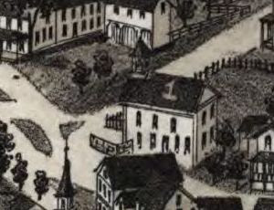
1. Congregational Church
The Second Congregational Church at 1 Middlefield Road in Chester. The exterior of the building remains much the same today as when the church was organized in 1844. Between that time and 1901, the church was served by over twenty successive ministers, the shortest pastoral term encompassing a mere two months and the longest around nine years. Half of the ministers spent one annum or less tending the Chester flock. The isolation and intensity of the harsh hill town winters probably had much to do with the high turnover rate of holy men, as well as the fact that many pastors preached a circuit, serving more than one area congregation at a time.

2. Methodist Church
Just east down Route 20 from the Second Congregational Church, the foundation of the Chester Methodist Church was laid in 1845, with construction complete and a formal dedication two years hence, in the autumn of 1847. A keg of gunpowder planted by those in opposition to members of the Methodist congregation's very active town temperance movement severely damaged the building when it exploded on the night of February 22, 1854. Repairs took months to complete, the church formally re-opening on August 6, 1854. The church ceased operating in that function in 1921, when members merged their flock with that of the Second Congregational Church. The structure was sold to the Samoset Lodge and then the Masons, and was shuttered in 1995.
The Chester Historical Society's, April, 2003, newsletter brings the Methodist Church building to life with a wonderful and comprehensive article detailing the structure's "storied past." Here's the link:
http://www.chestermass.com/Chester_Historical_Society/Newsletter/2003_April.pdf

3. Town Hall/Public School
The manufacturing and population growth explosion of the village of Chester Factories in the late Industrial-period resulted in the relocation of the town's civic offices there in 1870 from the original Chester Center, over 3 1/2 miles to the northeast. Chester's municipal building in 1885 combined civic and educational space. Today, the Chester Town Hall, at 15 Middlefield Road, (aside from being the place to take care of town business) is where the very talented and creative Chester Theatre Company holds its performances. The Chester Theatre Company is celebrating its 20th year in 2010 and is trying something new to raise production funds with its 1st Annual Winter Online Auction, to be held this March from the 21st to the 28th. To support this worthy cause, visit the Theatre Company's web site:
http://www.chestertheatre.org/index.cfm?CFID=2159403&CFTOKEN=23869293
And here's a link to the official Town of Chester web site:
http://www.townofchester.net/chestermass/

4. White's Hotel - W. R. White
Opened around 1882, William Roland White's hotel was virtually brand-new when Burleigh's map was created in 1885. Illustrated then in its 19th century location at the intersection of Depot and River Streets, today the building presides over the corner of Chester's Main and Riverfront Streets. Never physically moved, the former hotel's new address comes courtesy of a renaming of streets. The structure has been physically altered, though, with the later addition of a second-floor porch among other changes. Here are links to a couple of postcards of the hotel when it was known as the Riverside Inn from the late Shirley Bruso's excellent collection of Jacob's Ladder images:
http://homepages.rootsweb.ancestry.com/~shirleyb/jacobsladder/riverside2.html
http://homepages.rootsweb.ancestry.com/~shirleyb/jacobsladder/hotel2.html
This photograph, snapped by Francis Seddon in 2003, shows the Italianate-style beauty as it enters the 21st century:
http://homepages.rootsweb.ancestry.com/~shirleyb/jacobsladder/seddonhotel.html
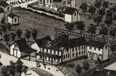
5. Chester House - W. H. Day
Within fifteen years of being drawn into map image immortality, William H. Day's Chester House, on the corner of Main Street and Middlefield Road, was razed to make way for a new school. Isaac Stevens was the first proprietor of the tavern, opening the doors to travelers in the early 1800s. The two and a half story, red-brick Chester Grammar School, which replaced Day's inn, has been a prominent landmark as one enters town since the dawn of the 20th century.

6. Hampden Emery Co. (Upper Mill)
The industrial abrasive, emery, was first detected after a visit to Chester on August 19, 1863, by Professor Charles T. Jackson, a Boston geologist who had been poking around for mineral samples in a mine owned by the Chester Iron Company. The mine had been worked unsuccessfully for a short span in the late 1850s after Dr. Heman S. Lucas's 1856 discovery of quantities of iron ore there and had restarted ore-extraction operations not long before Jackson revealed his findings to Lucas. Lucas confirmed the emery deposit several weeks later, the first major vein recorded in the United States.
Here's a link to a great article on Dr. Heman S. Lucas and the Chester emery trade by historian John Garvey, published in the May, 2006, newsletter of the Chester Historical Society:
http://www.chestermass.com/Chester_Historical_Society/Newsletter/2006_May.pdf
And here's a link to an 1865 article in Volume 89 of the American Journal of Science by Professor Jackson, describing the discovery of emery in Chester in his own words:
http://books.google.com/books?id=o_cQAAAAIAAJ&dq=charles%20jackson&pg=PA87#v=onepage&q=charles%20jackson&f=false

Hampden Upper Mill
It is a sign of the times that in 1885, mills and industrial enterprises - complete with belching smokestacks - would be featured as map insets. Development and progress were admired and encouraged in the late 19th century, the American dream being reshaped and reformulated in a nation transformed by upheaval, content to look forward (indeed, driven to) lest the bloody past of a country divided overtake a prosperous future.

6. Hampden Emery Co. (Lower Mill)
The 1863 discovery of emery in Chester brought its own form of abrasive personal and commercial upheavals. The Chester Iron Company was quickly reorganized as the Chester Emery Company, the principals being Dr. Heman S. Lucas, Henry D. Wilcox, James T. Ames and John E. Lucas, Heman's brother. Trying to squeeze iron out of rock was soon forgotten as profitability in the emery trade ensued. No longer dependent on importation of emery from Turkey or Greece, companies nationwide contracted with the Hilltown firm to provide them with the mineral, resulting in the rapid growth of the Chester Emery Company within the first few years of its incorporation.
By 1868, James Ames was overseer of the emery company and the Chester mines - gaining the top spot per vote of the board of directors - and Dr. Heman Lucas was out. The Hampden Emery Company was formed in all due haste, with Dr. Lucas, Henry Wilcox and Professor Jackson at the helm. The industrial rivals slugged it out in court over the next several years, each asserting rights to the mines with the Chester Emery company ultimately emerging the winner of the six-year skirmish.
The mills of the Hampden Emery Company managed to stay open after the court decision using ore imported from Turkey. Dr. Lucas, seeking other sources of the mineral, purchased land in North Carolina where emery had been located and, shortly after, began mining operations there, securing a steady supply of the industrial necessity for his factories back home before a year had run out on the legal setback his firm had suffered. The 1883 death of his former partner and competitor James Ames brought the deeds to the Chester emery mines back into the hands of Dr. Heman Lucas and the Hampden Emery Company, the rights to the properties purchased by the firm soon after Ames's passing. Lucas himself passed away in 1900. Around 1913, the Chester emery mines were closed.

Hampden Lower Mill
Dr. Heman Lucas's travails weren't limited to acts of man. The New York Times reported on July 14, 1874, that flooding in Chester had resulted in $10,000 worth of damage to one of the mills of the Hampden Emery Company. The Hannum Edge Tool Company - another concern of Lucas's - also sustained damage during the leveling display of nature's wrath. Many farms (including Lucas's fifty-acres) were affected by the raging waters, so powerful that Chester buildings were moved from their foundations and spun, left facing compass points anew. Four bridges were swept away and many roads were washed out in the deluge, which affected just about every resident in town. 1874 was a bad year for floods in Western Massachusetts, the Williamsburg reservoir dam on the Mill River in neighboring Hampshire County bursting under heavy rainfall two months earlier, on May 16, 1874, resulting in a loss of 139 downstream souls.
Here's a link to a previous
EWM map post detailing an 1854 map of Hampshire County which, oddly enough, includes Chester Village although Chester had become part of Hampden County when that county was created from Hampshire County acreage on February 25, 1812:
http://explorewmass.blogspot.com/2009/07/map-hampshire-county-massachusetts-1854.html

7. Grant Corundum Wheel Co.
According to the
Report of the Tax Commissioner of the Commonwealth of Massachusetts, published in 1889, grinding wheel manufacturer Grant Corundum Wheel Company, was certified an organization on November 14, 1882. Company owner Frank Grant's business, which had relocated to Chester around 1880 from Manchester, NH, was somewhat and unfortunately short-lived, burning to the ground in 1892.
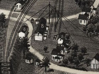
8. Chester Granite Works
Although it had to be hauled into town over three miles along the Chester & Becket Railroad from where it was quarried in Becket to be worked, the blue-hued granite of Becket became known as "Chester dark" and "Chester light" to geologists, a sample's classification determined by the amount of black mica tinging the stone. In 1885, granite quarrying, cutting and polishing was growing into an important industry in Chester, the fine-grained stone highly desirable for its monument-quality texture. Today, one can visit the Chester-Hudson Quarry at Becket and step back into the past, thanks to the hard work and dedication of the folks at the
Becket Land Trust and those who contribute to their awesome endeavors. Here's a link for more information:
http://www.becketlandtrust.org/quarry/index.htm

9. James Keefe's Quartz Mill
Perched on the edge of Walker Brook, right upstream from where the West Branch of the Westfield River runs into it on the way to meet her two sister branches, Keefe's Quartz Mill was just one of several commercial concerns owned by the Keefe family of Chester. Quartz exists in abundance in the area, and when ground, finds its profitability in its use in the production of porcelain. James Keefe served with the 46th Massachusetts regiment during the Civil War, one of many Chester men who fought for the Union.

10. Chester Tannery
In 1885, tanning - making leather from animal skins - was the primary industry in Chester, the tannery along Walker Brook one of three processors in town. According to the 1982 Massachusetts Historical Commission's Reconnaissance Survey Town Report for Chester, thirty-percent of Hampden County's 1885 leather production originated from Chester tanneries. Here's a link to the Commission's Report:
http://www.sec.state.ma.us/MHC/mhcpdf/townreports/CT-Valley/cht.pdf

11. Chester Grist Mill
A grist mill was a vital part of every town before the days of packaged bread and preservatives. Chester Grist Mill harnessed the hydro-power of Walker Brook to grind grain to flour. The seasonal Bisbee Mill Museum in nearby Chesterfield (66 East St.) offers visitors a chance to see a refurbished early-1800s grist mill. The museum is open Sundays 2-5, from June to October. Here's some more information, courtesy of the Jacob's Ladder Business Association:
http://www.jlba.org/Tourism/bisbee_mill.html

12 McGeoch & Co.'s Bedstead Factory
Surrounded by heavily wooded forest and graced with a strong flow of running water, Chester visionaries and entrepreneurs took advantage of the opportunities afforded them, sawmills and comb factories, bedstead, bobbin, crib and furniture makers springing up along river and stream banks, water wheels churning out the future.

13. Smith's Carriage and Sleigh Manufactory
Smith is a surname long-associated with the Town of Chester. In the 1911 New England Historic Genealogical Society reference work,
Vital Records of Chester, Massachusetts, to the Year 1850, there are over five pages of Smith births, three pages of marriages and a bit more than two pages of deaths.

7. Grant Corundum Wheel Co.
14. T. Keefe's Bedstead Factory
Timothy Keefe was an active citizen in Chester trade and civic affairs. In addition to owning the bedstead factory on Middlefield Road, Keefe was proprietor of a general store, which he later handed down to his son, James, owner of the Quartz Mill on Walker Brook. The store had initially been opened by partners William Shepard and Hiram Barber in the village of Chester Factories in the early 1800s . Timothy Keefe was town clerk from 1863 to 1871, and was also important to the village's public library, serving as trustee.
By 1904, Keefe's Bedstead Factory and the remnants of Grant Corundum Company had been replaced by the brand-new facilities of the Hamilton Emery Company, under the direction of company founder, Frank Hamilton. Here's a link to the Chester Historical Society's feature article commemorating the firm's 100th anniversary in the society's, March, 2005, newsletter:
http://www.chestermass.com/Chester_Historical_Society/Newsletter/2005_March.pdf

15. B. & A. Round House
On May 15, 1833, the Western Railroad Corporation was established and charged with extending the Boston & Worcester Railroad to Massachusetts' western border. In October of 1839 the first train arrived in Springfield from Worcester. By May 24, 1841, trains were running as far west as Chester Factories, bringing a new avenue of prosperity to the village. As the massive rail transportation project moved toward the New York border, Chester's importance grew to the line, becoming a certain stop so that pusher locomotives could be added to passing trains in order to assist them in surmounting the unforgiving grades around Gobble Mountain and Walnut Hill and westward to Washington and beyond. The workhorses of the Western railroad were stored in the round house, with a turntable guiding them into their respective resting places. The Western Railroad had been renamed the Boston & Albany Railroad by the time L. R. Burleigh's map was produced in 1885. A view from Google Earth shows the dirt circle tracing of the turntable and remnants of the round house still in place.

16. B. & A. R. R. Station
The Boston & Albany Railroad Station in Chester, though never reborn with the grand architecture of others along the line, was a welcome sight before the days of dining cars, many a hungry wayfarer disembarking an ever-swaying carriage into the warm glow of the eatery located there while the yardmen went about the business of coal and water amidst the pulses of steam and the clanging of bells, the explosive clash of locomotives connecting for the climb ahead purposeful and true. Today the station is lovingly maintained by the Chester Foundation and is open for visits seasonally, by appointment or during special events. For some incredible photographs and history and more information about making a trip out to the tracks, visit the Chester Railway Station web site:
http://www.chesterrailwaystation.org/

17. Post Office
One can read books, scan reports and peruse old newspaper articles for weeks and still never know as much about a town as you would if you were a fly perched on the wall of the local Post Office for the day.

18. Skating Rink
After all of the granite-quarrying and emery-bonding and shepherding and leather-making. After all of the grain was milled and bedsteads were made and tables were waited. After the stores closed and the quartz was ground, the good folks of Chester were able to unwind at the skating rink, to strap wheels to their soles and roll away the night in spinning social circles of small town Western Massachusetts. One can't help but feel that the people who sprung from and worked this hard, rocky soil deserved every moment of joy they could find in 1885.
As always, thanks for stopping by and take care.
* * *
For more maps - modern and historic - visit the
EWM page,
Trails, Rails & Roads: Western Mass. Maps. For best results viewing the above map and others at EWM, save images and view in a photo program with a zoom feature.
Map Source: Library of Congress; American Memory; Map Collections; Troy, N.Y.: L.R. Burleigh, [1885] (Milwaukee, Wis. : Beck & Pauli, litho); Digital ID: g3764c pm010820 http://hdl.loc.gov/loc.gmd/g3764c.pm010820
Home|Welcome|Table of Contents|Explore|Upcoming Events|Patrons|Marketplace|Contact|Privacy


