Showing posts with label Commerce/Industry. Show all posts

Wednesday, January 30, 2013

United States Post Office, Lee, MA - c1910

United States Post Office, Lee, MA, c1910

Settled in 1760 and incorporated in 1777, the town of Lee is one of the gems of the Berkshire hills.

In 1910, according to the U.S. census, the population of Lee was 4,106. In 2010, the head count was 5,943. Paper mills, stone and limestone quarries were a few of the town's early industries.

Marble quarried within the town's 27 square miles is known for its fine quality and graces such sites as St. Patrick's Cathedral in New York City and the U. S. Capitol building in Washington, D.C.

Although they are home to new enterprises now, the buildings in the photograph above can still be found along Lee's charming Main Street, witnesses to the past 102 years and looking none the worse for the wear.

As always, thanks for stopping by and take care.


Photograph source: Library of Congress; Prints and Photographs Division; Washington, D.C. 20540 USA; Reproduction No.: LC-USZ62-33801; http://www.loc.gov/pictures/item/2012649405/


Official town website: http://www.lee.ma.us/


Wednesday, March 9, 2011

A Main Street Moment, North Adams, c1908


Still damp from a recent pass of the watering wagon, Main Street, North Adams, stands frozen eternal, the calendar forever turned to 1908.


Amidst the bustle, a pair of barefoot boys stop to examine a window full of magic. Posters proclaim: The circus is coming to town!


Main Street's commercial offerings include druggists and (painless) dentists, loans and lunch.


On steel rails slicing the center of the street, a streetcar runs its rounds: Unshackled from the horse team only to be bridled to the wire.


Drivers and cyclists and folks on foot are caught in the camera eye unaware, life forever paused on a dry plate negative.


The sidewalk has long since dried in front of Wilson department store, the people have moved on. For though the moment's before us, time waits for no one.

As always, thanks for stopping by and take care.


More on EWM...

Map: Bird's-eye View of North Adams, 1881: http://explorewmass.blogspot.com/2009/04/map-birds-eye-view-of-north-adams-1881.html


Photo source: Library of Congress; Prints and Photographs Division; Detroit Publishing Company Photograph Collection; Call Number: LC-D4-70516; http://www.loc.gov/pictures/item/det1994020399/PP/

Home|Welcome|Table of Contents|Explore|Upcoming Events|Patrons|Marketplace|Contact|Privacy


Tuesday, March 8, 2011

Map of Franklin County, Mass., c1879

Franklin County, Mass., c1879

Late 19th century Franklin County is represented in this small slice of the A. Williams & Company Railroad & Township Map of Massachusetts, published in 1879 at the Boston Map Store and printed by lithographers J. Mayer & Company.

Formerly part of Hampshire County, Franklin was relatively young in 1879, born by act of the state legislature on December 2, 1811.  On July 1, 1875, according to state census figures, the population of Franklin County was 33,696. The land those folks owned had a total monetary value of  $16,579,435, as recorded May 1, 1875.

The map notes both population and property value for each town. Post routes criss-cross the county,  each circle along the road a post office, with distance in miles between stops noted accordingly. The offices with double circles sell money-orders.

As always, thanks for stopping by and take care.


More about Franklin County...

Here is a link to the Franklin County segment of the History of the Connecticut Valley in Massachusetts (1879), by Louis H. Everts, featured on the Western Mass. History & Genealogy website (an excellent resource): http://www.franklincountyhistory.com/everts/index.html

From EWM...

Photographs: A Fall Farm Stand in Franklin County, October, 1941: http://explorewmass.blogspot.com/2009/10/photographs-fall-farm-stand-in-franklin.html

Motoring the Mohawk , October 1941: http://explorewmass.blogspot.com/2008/10/motoring-mohawk-october-1941.html

A Walk Around Greenfield (circa 1903): http://explorewmass.blogspot.com/2009/05/walk-around-greenfield-circa-1903.html

Cemetery: Old Deerfield Burying Ground: http://explorewmass.blogspot.com/2007/07/cemetery-old-deerfield-burying-ground.html


Map source: Library of Congress Geography and Map Division; Digital ID: g3760 rr002350; http://hdl.loc.gov/loc.gmd/g3760.rr002350; http://memory.loc.gov/cgi-bin/query/r?ammem/gmd:@field(NUMBER+@band(g3760+rr002350))

Home|Welcome|Table of Contents|Explore|Upcoming Events|Patrons|Marketplace|Contact|Privacy


Monday, March 7, 2011

This Month in Western Massachusetts History: March


BORN:

2 Mar 1904 - Theodor Seuss Geisel, aka Dr. Seuss - (2 Mar 1904 - 24 Sept 1991) - Author; Illustrator, Green Eggs and Ham, etc. - Born and raised in Springfield

5 Mar 1955 - Penn Fraser Jillette - (5 Mar 1955 - ) - Illusionist; Magician; Entertainer - Born and raised in Greenfield

12 Mar 1948 - James Vernon Taylor - (12 Mar 1948 - ) - Grammy Award-winning Musician, Member of the Rock & Roll Hall of Fame - Resident of Washington

17 Mar 1951 - Kurt Vogel Russell - (17 Mar 1951 - ) - Actor, Silkwood, etc.; Baseball Player - Born in Springfield

26 Mar 1850 - Edward Bellamy - (26 Mar 1850 - 22 May 1898) - Author, Looking Backward 2000-1887 - Born and died in Chicopee Falls

26 Mar 1874 - Robert Lee Frost - (26 Mar 1874 - 29 Jan 1963) - Pulitzer Prize-winning Poet; English Teacher at Amherst - Lived in Amherst

27 Mar 1969 - Johnny April - (27 Mar 1969 - ) - Musician; Drummer, Staind - Resided in Springfield


DIED:

13 Mar 1906 - Susan Brownell Anthony - (15 Feb 1820 - 13 March 1906) - Temperance Activist; Abolitionist; Suffragette - Born in Adams

16 Mar 1985 - Edward William (Eddie) Shore - (25 Nov 1902 - 16 Mar 1985) - NHL Hockey Player; Player, Owner, AHL's Springfield Indians - Resided and died in Springfield

19 Mar 1988 - Estelle Condit (Suzy) Frelinghuysen - (1911 - 19 Mar 1988) - Abstract Artist; Opera Singer, Philanthropist - Married to George L. K. Morris - Resided in Lenox

22 Mar 1785 - Jonathan Edwards - (5 Oct 1703 - 22 Mar 1785) - Fervent Preacher; Theologian - Lived in Northampton

22 Mar 1798 - Justin Morgan - (28 Feb 1747 - 22 Mar 1798) - Composer; Horse Breeder, Morgan Horse - Born and lived in West Springfield

24 Mar 1882 - Henry Wadsworth Longfellow - (27 Feb 1807 - 24 Mar 1882) - Professor; Poet, Paul Revere's Ride, etc. - Resided in Pittsfield


HAPPENED:

Mar 1643 - Springfield settlers vote to build a bridge over the Mill River in Springfield.

Mar 1648 - The section of Springfield known to natives as Woronoko is annexed to create Westfield. Springfield had acquired the land per an order of the General Court in 1647.

Mar 1750 - Residents of South Hadley, requiring more space for worship and civic affairs, vote at assembly to build a new meeting-house. Fifty meetings and thirteen contentious years later, the structure is finally built.

Mar 1847 - Springfield's Main Street train station burns beyond repair. It is replaced with a larger, brick structure.

Mar 1848 - With debate whether to advance from town to city growing, a committee of the state legislature sitting in Springfield is presented with opinions pro and con.

Mar 1931 - The aqueduct connecting the Ware River and Wachusett Reservoir is completed, as Boston looks west to increase fresh water supplies to the city and its suburbs.

Mar 1674- Ferry service is established on the Connecticut River, just south of inlet of the Agawam (now the Westfield River). The ferry shuttled passengers, animals and freight across the river at this spot for almost 200 years, until the construction of the South-end bridge in 1879.

1 Mar 1651 - Joshua Parsons, young son of Hugh and Mary Parsons, passes away, leading an already-unnerved Mary to declare her husband a witch and murderer to Magistrate Pynchon, confirming many Springfield residents' suspicions. Mary, claiming to be possessed by Satan, recanted her story shortly after, taking responsibility for the death of the boy. Joining her jailed husband in Boston, she was held for trial. Although Mary was exonerated on the charge of being witch, she was convicted in May, 1651, and sentenced to death for Joshua's murder. Too sick to be hanged on the scheduled day, Mary was found dead in her cell on the next. Hugh Parsons was also convicted, but ultimately was spared the hangman's noose, leaving the area in due haste.

1 Mar 1842 - The Northampton and Springfield railroad corporation is formed.

2 Mar 1798 - The Berkshire County town of Clarksburg is incorporated.

3 Mar 1802 - West Springfield grows in area with the annexation of Westfield land.

4 Mar 1629 - King Charles I grants charter to the Company of the Massachusetts Bay.

4 Mar 1816 - Enfield holds its first town meeting. Enfield was one of four Massachusetts towns disincorporated in 1938 to make way for the Quabbin Reservoir, part of Boston's water-supply system.

6 Mar 1762 - The Franklin County town of Bernardston, formerly known as Falltown, incorporates.

6 Mar 1762 - The Berkshire County town of Sandisfield is incorporated.

6 Mar 1762 - The town of Tyringham, in Berkshire County, is incorporated.

6 Mar 1930 - Frozen food makes its worldwide debut as seven markets in Springfield offer curious patrons a variety of Clarence Birdseye's icy edibles for the first time in history.

7 Mar 1888 - The Springfield Daily Union newspaper offices on the corner of Main and Worthington Streets are swept up in a rapidly spreading fire, causing several deaths and injuries. Some victims jumped from the upper floors, where fire had trapped them. Others met their end in the blaze itself, unable to get out of the building. The tragic event prompted the city to buy the fire department's first aerial ladder.

7 Mar 1938 - Dana holds its last town meeting. The Swift River Valley town (and three others) would cease to exist on April 28, 1938, drowned by the man-made Quabbin Reservoir, a massive undertaking to expand Boston's water supplies.

9 Mar 1848 - Main Street, Springfield, was a somber scene as the body of President John Quincy Adams passed mourning dignitaries, military companies, politicians and residents on its way to First Church at Court Square.

9 Mar 1855 - The town of Norwich changes name to Huntington.

11 Mar 1864 - The Westfield Athenaeum is incorporated by legislative act.

12 Mar 1783 - The Hampshire County town of Middlefield is established.

12 Mar 1830 - The Massachusetts railroad corporation is established. The corporation's mission is to build a railroad between Boston and the Hudson river near Albany or Troy by January 1, 1835, passing through Springfield.

14 Mar 1793 - Cheshire is incorporated as a town in Berkshire County.

14 Mar 1805 - Great Island, in the Connecticut River, is annexed to the town of Gill, effective April 1, 1805.

15 Mar 1833 - The Western Railroad Company is established by charter of the Massachusetts legislature. The incorporation is charged with extending the western end of the Boston and Worcester railroad to the state's border with New York.

16 Mar 1854 - Holyoke firm Lyman Mills is incorporated.

16 Mar 1868 - The Springfield Street Railroad Company is incorporated. Before electrification, the rail cars were pulled by teams of horses

17 Mar 1801 - Dana holds its first town meeting.

20 Mar 1651 - Hugh Parsons, accused of witchcraft, is brought from Springfield to Boston to stand trial.

20 Mar 1784 - The town of Dalton is incorporated in Berkshire County.

20 Mar 1837 - The Westfield - Southwick border is adjusted.

21 Mar 1785 - Heath holds its first town meeting.

21 Mar 1936 - Springfield and other Connecticut River towns are devastated by a major flood.

21 Mar 1940 - Quabbin Reservoir receives its first flow of water from Ware River diversion. Quabbin reaches full capacity on June 22, 1946, 412 billion gallons.

25 Mar 1938 - Enfield Town Hall serves as site of town's farewell gathering, an emotional night well-attended by residents and friends alike. Just over a month later, Enfield is no longer, officially disincorporated to make way for the Quabbin Reservoir.

26 Mar 1855 - The border between Northampton and Easthampton is defined.

28 Mar 1938 - Final plans are filed by the Metropolitan District Water Supply Commission for the massive land-taking required for the creation of Quabbin. In all, 117 square miles become watershed property. By the year 2005, the reservoir quenches the thirst of over 2.2 million people in eastern Massachusetts daily.

31 Mar 1933 - The Civilian Conservation Corps is created as a result of the Reforestation Relief Act. The Corps was also referred to as the "3 Cs". Taming Holyoke's Mt. Tom State Reservation was one of the first local projects the Corps tackled.


Home|Welcome|Table of Contents|Explore|Upcoming Events|Patrons|Marketplace|Contact|Privacy

Sunday, March 6, 2011

A Ride on the Mt. Tom Railroad, Holyoke

Electricity, entrepreneurship and an eye for entertainment transformed the highest peak on the Mt. Tom Range from a knuckle in the stone spine of the Metacomet Ridge into the happening local destination of the 1890s and beyond, thanks to William S. Loomis, owner of the Holyoke Street Railway Company.

As a Holyoke businessman dissatisfied with the pace of the street railway's line expansion, Loomis decided to take matters into his own hands, purchasing the four-year old company outright in 1888. Electrification of the lines came in 1891 and, despite a faltering economy, the Holyoke Street Railway grew apace under his ambitious stewardship.

In 1895, Loomis's railway began shuttling weekend passengers in search of respite and recreation to a 365-acre parcel on Holyoke's Mt. Tom that he had purchased and begun to groom some years before. Opened in 1894 and named Mountain Park, the new connection to the Holyoke Street Railway resulted in a steady increase of visitors and profits.

In 1897, with a state charter to build a pleasure resort in hand, Loomis strove to make his vision blossom, adding a restaurant (with open-air dining), a dance hall, and a 2,500-seat theater named The Casino. A unique switchback railway (a new type of roller coaster, the first of which had been built just 13 years before at Coney Island, NY) beckoned the daring soul, with a merry-go-round and water ride providing additional, less-challenging, amusement.

The Holyoke Street Railway's weekend trolley park on the mountain served both pleasure and profit, with day-off fares proffered by grateful workers free on holiday to board trains that would else sit idle as a Sunday factory: Indeed, a combined natural win for both city folk and stakeholder.


Mountain Park & Mt. Tom Summit House, Holyoke, Mass., between 1900-1910
No self-respecting turn of the 20th century mountain resort was without a crowning summit house. Locally, proprietor William Street's Eyrie House hotel and resort had perched at the apex of Holyoke's Mt. Nonotuck for 36 years - the summit house atop Mt. Holyoke in one form or another for much longer - by the time the Mt. Tom Summit House opened in 1897. The fresh and fierce competition for patrons, coupled with a calamitous fire, drove William Street from the pleasure business into bitterness and seclusion by 1901. Mt. Holyoke's summit house fared better, operating as the Mt. Holyoke Hotel into the 1930s.


Lower station, Mt. Tom Railroad, Holyoke, Mass., between 1905-1915
Key to the success and popularity of the Mt. Tom Summit House as a satellite of Mountain Park, despite its location atop the highest peak of the Mt Tom Range, was the construction of the Mt. Tom Railroad in 1897. An offshoot of the Holyoke Street Railway Company, the two lines' convenient connection at Mt. Tom's lower station made the steep, uphill climb a painless, even pleasurable, experience for patrons.

In the photo above, cars of the Holyoke Street Railway service passengers at the lower station platform. Access to the Mt. Tom Railroad is on the opposite side of the station.


Mt. Tom Railroad elevating car, The Elizur Holyoke, between 1900-1920
The Mt. Tom Railroad was uniquely engineered to master the steep, uneven terrain using two special elevating cars, designed with seats that automatically leveled themselves to the immediate incline for passenger comfort. Each car could carry up to 80 fares.

The duo were named in honor of contemporaries Elizur Holyoke and Rowland Thomas, 17th-century surveyors of the area from the down river settlement of Springfield and namesakes of Mt. Holyoke and Mt. Tom. Elizur Holyoke married Springfield settler and magistrate William Pynchon's daughter Mary in 1640, the first marriage recorded in Springfield.


 The Rowland Thomas, after passing turn-out, between 1905-1915
With two cars shuttling passengers on one line, it was necessary to incorporate a turn-out, or bypass, on the Mt. Tom Railroad constructed to be capable of allowing the overhead electric cables of each car to pass unimpeded on their meeting.

In the photo above, the Rowland Thomas (foreground) climbs toward the Mt. Tom summit after passing the Elizur Holyoke, the turn-out visible between them.


The Elizur Holyoke climbs Mt. Tom, Holyoke, Mass., between 1905-1915
Basalt barriers blasted, mountain flora cut to earth: a mile of wooden ties and steel racks were tacked to rugged stone slope to create the Mt. Tom Railroad, linking Mountain Park and the Mt. Tom Summit House, 700-feet above. Bordered by traprock piles, desolate in their displacement, the railroad's construction cut what would be a time-consuming - or even impossible for some - on-foot ordeal into a short, 10-minute ride to the top, accessible to anyone with the price of the fare, twenty-five cents (as recorded in 1912).


Approaching Mt. Tom Railroad's upper station, between 1900-1906
The Elizur Holyoke appears in the distance climbing toward the Mt. Tom Railroad's upper station. The two cars on the line, as well as the upper and lower stations, were linked by telephone, affording ease in communication and providing an extra level of safety and service. A full-service telephone was available for public use at the Mt. Tom Summit House.


The Elizur Holyoke crests the final rise of the Mt. Tom Railroad, between 1900-1906
Trade union publication, The Railroad Trainman, with an appreciative eye for the innovative, took note of the newly-built Mt. Tom Railroad in its July, 1898, issue:
"The summit of Mt. Tom was not easily accessible until the construction of the Mt. Tom Railroad in the year 1897. Now, the street cars of Holyoke (which connect with the Springfield system of street cars, and with the Boston & Maine and N. Y., N. H. & Hartford railroads) run to the lower station of the Mt. Tom Railroad, and in less than ten minutes afterward the mountain cars deliver their passengers on the summit. The Mt. Tom Railroad is a cable-trolley-electric, modern mountain railway. The two cars are connected, and balanced by a 1 1/4 inch tested steel cable, made of 120 steel wires, twisted into the six minor cables which form the strong steel rope which runs over an eight-foot sheave at the top of the incline."
Electric brakes were backed up by an automatic, speed-sensitive braking system, as well as a cable brake. Power to spark the whole line traveled through pole-supported electric wires from a generating source five miles distant.


Pulling into upper station on the Mt. Tom Railroad, between 1900-1906
President William McKinley and First Lady Ida were very important passengers on the Mt. Tom Railroad on an outing to the Mt. Tom Summit House in 1899. The 25th president of the United States, accompanied by Massachusetts governor Roger Wolcott, was taking in the local sights while visiting Western Massachusetts to attend his niece Grace's June 20th graduation from the esteemed Mt. Holyoke College. Re-elected to a second term in 1900, McKinley perished September 14, 1901, assassinated by an angry anarchist at the age of 58. McKinley was the last sitting president to have served in the Civil War and the first to be captured on film in a 'moving picture.'


Upper station, Mt. Tom Railroad, Holyoke, Mass., between 1905-1915
Over a thousand feet above sea level, the vista outside the Mt. Tom Railroad's upper station exploded in stretching immensity, offering striking, breathtaking views of the valley and beyond. Visitor conquerors of the jagged cap of Mt. Tom Range alighted in the heavens from electric chariots full-lunged and fresh, ready to enjoy the amenities and entertainment scattered about the peak for their pleasure.

Steps away from the upper station beckoned the Mt. Tom Summit House - perched on a basalt tor defiant - with its maps and telescopes, sitting nooks and myriad wide windows inviting visitors to drink in the distant and near. The top-notch Top-O-Tom restaurant provided an upscale ambiance to the rugged natural surroundings offering diners both fine food and magnificent views in a classy atmosphere. The establishment was noted for its unique, ivy-covered interior walls.


The Mt. Tom Summit House, Holyoke, Mass., between 1905-1915
The original Mt. Tom Summit house, built in 1897, was destroyed by fire on October 8, 1900. The Holyoke Street Railway Company wasted no time rebuilding, employing laborers over the winter to work post haste to replace the profitable asset with an even bigger and better version. On May 15, 1901, the new Mt. Tom Summit House (above), complete with golden dome, 300-person capacity hall, and 3,920 square-foot, glass-enclosed upper observation deck, opened for business.

The imposing, seven-story tall structure served as a focal point of the valley and a day trip destination until its own demise by fire in 1929. A small building made of metal was constructed on the spot as a replacement, but, as growing automobile ownership expanded folk's choices, and increased competition for recreation revenue coupled with the onslaught of the Great Depression, the once-keen popularity of the Mt. Tom Summit House failed to rebound. The land became the seed for Mount Tom State Reservation, groomed by the Civilian Conservation Corps beginning in 1933, and still serves today as a piece of public paradise.

In 1938, the last summit house and the Mt. Tom Railroad were dismantled and sold for scrap, an ignominious exit for a vibrant era fast fading to sepia-toned memories.

Mountain Park, having marked its share of ups and downs navigating the past 117 years, has enjoyed a more illustrious and lasting legacy than its satellite in the sky, persevering in various forms and configurations until the end of the 1987 season, when its gates closed for what sadly appeared to be the last time.

Fortunately, the 60 acres that had been the heart of Mountain Park through the decades remained in private hands and were purchased in 2006 by local visionary and entrepreneur, Eric Suher, who entertains dreams of restoring the park of locals' memories. Generations apart, William Loomis and Eric Suher complete a century circle of commercial creativity and inspiration, promoting the hard acres of Mt. Tom, inventing and re-inventing the happy world of Mountain Park. Well-attended concerts organized by Mr. Suher in 2009 and 2010 breathed life into the dormant and dismantled park, public support for Mr. Suher's endeavors on display in the enthusiastic turn-out for the shows.


View of Easthampton from Mt. Tom, Holyoke, Mass., c1908
On his 1899 visit, President McKinley declared the view from Mt. Tom "the most beautiful mountain out look in the whole world." Perhaps had he enjoyed the opportunity on his trip to visit more of the several summits standing sentinel above the Pioneer Valley, witnessing perfection in constant laid out below, he would have expanded his generous summation to reflect what locals truly know: Western Massachusetts is the most beautiful place in the world.

As always, thanks for stopping by and take care.


Explore more...

One ride from Mountain Park that can still be ridden is the 1929-built merry-go-round, relocated and still spinning at a buck a ride beneath a wonderful recreation of its original pavilion at Holyoke's Heritage State Park. For more information, visit the Holyoke Merry-Go-Round website at: http://www.holyokemerrygoround.org/

Wistariahurst Museum in Holyoke maintains an excellent website, Chariots of Change, chronicling the history of the Holyoke Street Railway Company, including interesting links to a large collection of digitized reference material: http://wistariahurst.org/holyokestreetrailway/introduction/

The website, Mt. Holyoke Historical Timelines, presented by Robb Strycharz, is an excellent resource that captures the symbiotic relationship between Mt. Holyoke, Mt. Tom, and Mt Nonotuck throughout their commercial development: http://www.chronos-historical.org/mtholyoke/index.html

In 1912, the Holyoke Street Railway Company - under the management of Louis D. Pellissier - published Views on and about Mt. Tom and of Mt. Tom railroad, an illustrated promotional tool for the resort. Louis Pellissier and William Loomis worked together for years molding the mountain acreage into a profitable business. Pellissier purchased Mountain Park in 1929 and operated it until 1952. Here's a link to the publication, digitized at the Internet Archive: http://www.archive.org/details/viewsonaboutmtto00pell

Here's a nice website with information and images, including the original Mt. Tom Summit House: http://www.mounttom.com/

Jay Ducharme, author of the book, Mountain Park (Arcadia Publishers), is the local authority on the park's history. Here's a link to his website: http://www.karenandjay.com/mtpark/mtpark.html

Plan your visit to Mt. Tom State Reservation in Holyoke with directions, printable trail map and more, courtesy of the Mass. Dept. of Conservation and Recreation: http://www.mass.gov/dcr/parks/central/mtom.htm

Check out the EWM channel on YouTube for a collection of vintage clips and videos of Holyoke history in motion: http://www.youtube.com/user/Explorewesternmass

Learn more about William Street, proprietor of the Eyrie House atop the summit of Mt. Nonotuck, with EWM post, The Eyrie House: William Street's Home in the Clouds: http://explorewmass.blogspot.com/2010/03/eyrie-house-william-streets-home-in.html

Take a photo-hike around Mt. Tom's Lake Bray with EWM post, A Misty Morning on the Bray Loop Trail: http://explorewmass.blogspot.com/2008/06/misty-morning-on-bray-loop-trail.html

EWM post The Federal Theatre Project Visits Mt. Park Casino features posters from the depression-era WPA Federal Theatre Project advertising shows at Mountain Park Casino: http://explorewmass.blogspot.com/2009/03/federal-theatre-project-visits-mt-tom.html


Photo source: Library of Congress, Prints and Photographs Division, Detroit Publishing Company Photograph Collection:
1: http://www.loc.gov/pictures/item/det1994006420/PP/
2: http://www.loc.gov/pictures/item/det1994021402/PP/
3: http://www.loc.gov/pictures/item/det1994002003/PP/
4: http://www.loc.gov/pictures/item/det1994021403/PP/
5: http://www.loc.gov/pictures/item/det1994021401/PP/
6: http://www.loc.gov/pictures/item/det1994005743/PP/
7: http://www.loc.gov/pictures/item/det1994005744/PP/
8: http://www.loc.gov/pictures/item/det1994009976/PP/
9: http://www.loc.gov/pictures/item/det1994021398/PP/
10: http://www.loc.gov/pictures/item/det1994021400/PP/
11: http://www.loc.gov/pictures/item/det1994019924/PP/


Home|Welcome|Table of Contents|Explore|Upcoming Events|Patrons|Marketplace|Contact|Privacy


Tuesday, January 11, 2011

Barney Demonstrates Skates at Forest Park


Everett Hosmer Barney (December 7, 1835 - May 31, 1916), Springfield resident and major benefactor of the city's Forest Park is probably best known for his invention of the clamp-on ice skate, for which he received his first patent in 1864.

One of Barney's many other patents, awarded in 1868, was for a perforating machine that could stamp the amount due on a check, or the words "canceled" and "paid."

Here Mr. Barney is seen demonstrating his prowess on his product in a photograph from the 1900 book, A Handbook of Figure Skating Arranged for Use on the Ice, written by George H. Browne, A. M., and published by the Barney and Berry Company in Springfield.

As always, thanks for stopping by and take care.

Tuesday, August 24, 2010

No Rest for Rust: Images of Becket's Hudson-Chester Quarry

Abandoned in the 1960s, the rusting remains of machines and materials dot the Hudson-Chester Quarry in Becket, on rescued land maintained for public use by the Becket Land Trust.

For more photos and information on this valuable and historic regional resource, visit the EWM post, The Historic Hudson-Chester Granite Quarry in Becket, Massachusetts.


Cylindrical Tank ~ Hudson-Chester Quarry

Top of Stiff-armed Derrick ~ Hudson-Chester Quarry

Truck Cooling Fan ~ Hudson-Chester Quarry (Nathaniel Hemingway Photo)

Steel Cable ~ Hudson-Chester Quarry

The Becket Land Trust welcomes volunteers and donations. To learn how you can help, visit http://www.becketlandtrust.org/

For more about Becket, Chester and mining in the Berkshires, check out the EWM posts, 'The Keystone Arch Bridges Trail: Magic in the Berkshire Mountains' and 'Map: Bird's-eye View of Chester, Mass., 1885.'

As always, thanks for stopping by and take care.


Home|Welcome|Table of Contents|Explore|Upcoming Events|Patrons|Marketplace|Contact|Privacy

Tuesday, August 10, 2010

The Historic Hudson-Chester Granite Quarry in Becket, Massachusetts

Becket Quarry Trail Map

You don't have to walk far up the trail into the historic Becket granite quarry to come face to face with yesterday. Less than half a mile from the ample parking lot, two abandoned trucks, a dilapidated electrical generator shed, the remnants of a stiff-arm derrick and other rusted ghosts of the granite harvesting trade greet visitors, at the area known as the quarry junction.


Electrical Generator Shed
The setting aside of more than 300 acres of Berkshire forest off Quarry Road in Becket, Mass. - including the old Hudson-Chester quarry - was made possible through the commendable generosity of town residents, whose financial contributions allowed the Becket Land Trust to acquire the plot for public recreation and historic preservation.

Hastening the process and lending urgency to the fund-drive was talk of the possible re-opening of the land for modern quarrying, a development Becket citizens preferred not see come to fruition lest the quiet, small-town character of the peaceful burg be changed.


Electrical Generator Shed (Nathaniel Hemingway Photo)
The Becket Land Trust will celebrate its 20th anniversary next year. According to the Trust's website: "The Becket Land Trust was founded in 1991 by a group of concerned citizens who were interested in maintaining the rural nature of the Town of Becket and of preserving its natural resources."

Perusing (and printing) the detailed area maps and history on the Trust's website is sure to add depth to your experience visiting the Hudson-Chester quarry. A kiosk in the parking area - maintained by the Trust - also provides printed resources to quarry explorers. To learn more about this valuable and necessary organization, and ways you can donate or get involved, head over to: http://www.becketlandtrust.org/.


Quarry Truck #1
Parked in forest pristine but for the vestiges of man, who was the last to walk away from the just-stilled engine, warm, beginning to tick its cooling contractions?


Quarry Truck #1
The Hudson-Chester Quarry was prolific in its produce, rail cars rolling blocks of granite to Hudson, NY and Chester, Mass. to be worked into monuments and tombstones, memorials carved to withstand the ages, cruel eraser of soft recollection. From the middle of the 19th century to the middle of the next, the Becket granite quarry cut stone prized for the quality of its grain.


Quarry Truck #2
Door swung open in invitation: Take her for a spin in your imagination. "Tis a drive into simpler times of hard-won, muscled reward, hearty hot meals and nights at home on porches under Berkshire stars. Unwinding, the Universe: Always unwinding.


Quarry Truck #2
No matter how many turns we make along the way, or how hard we crank the wheel, there is only one direction we are steering: Into the future.


Remnant of Stiff-Armed Derrick
The last slab of granite rolled down the track generations ago, a toppled loading hoist rests on the south side of the quarry junction, a splintered appendage once integral to mining operations. Stiff-armed derricks are also known as stiff-leg derricks, a type of crane used in quarries internationally.


Remnant of Stiff-Armed Derrick
Wood and iron and steel-braided cable return to the earth drippingly slow, layers of leaves and passed forest flora speeding to decomposition in comparison. Chronology intertwined but snowflake different: Not every moment spans the same length of time.


Mobile Power Source
Where once activity whirred and roared, creaked and grumbled with stones heavy as hearts storing wishes unfulfilled, the breathing now are greeted with a silence that even the lazy-stirring August leaves can't break. They wait, these machines, broken and twisted. They wait for the quarrymen, arms strong and tan in the afternoon sun, gone these five long decades past and not likely to return.


Granite Blocks
And the garden of granite surrounds us. In the magical Berkshire hills. In the bustling cities of America. We build our caverns where we don't find them and find them where they lay. Waiting. Cold canvases ready for the chisel. Ready for a human hand to set the names, to tell the dates, to memorialize our being.

As always, thanks for stopping by and take care.

For more information about Becket, railroad development and granite quarrying in the area, visit previous EWM posts, 'The Keystone Arch Bridges Trail: Magic in the Berkshire Mountains' and 'Map: Bird's-eye View of Chester, Mass., 1885.'


Home|Welcome|Table of Contents|Explore|Upcoming Events|Patrons|Marketplace|Contact|Privacy

Wednesday, July 28, 2010

Hampden County Memorial Bridge Spans Another Year Serving Western Mass.

The Hampden County Memorial Bridge (circa 1935-45)

The Hampden County Memorial Bridge is a vital link spanning the Connecticut River between the City of Springfield and the Town of West Springfield.

The magnificent structure was designed by architectural firm Fay, Spofford & Thorndike, in conjunction with Haven & Hoyt, architects, and its construction was contracted to H. P. Converse & Company, builders, on April 3, 1920. Fay, Spofford & Thorndike were retained as architects again in 1996 for the bridge's rebuild, contracted to the construction company, Daniel O'Connell's Sons.

The 1,515 foot-long Memorial Bridge was officially dedicated on August 3, 1922, "to those who had died as pioneers, and soldiers in the Revolutionary, Civil and Foreign Wars."

For more about the Memorial Bridge and the Toll Bridge that preceded it, check out previous EWM posts, Postcards: Hampden County Memorial Bridge and Postcards: The Old Toll Bridge Springfield, Massachusetts.

As always, thanks for stopping by and take care.


Home|Welcome|Table of Contents|Explore|Upcoming Events|Patrons|Marketplace|Contact|Privacy

Sunday, April 25, 2010

Tekoa Reservoir, Montgomery, Massachusetts


Although the image preserved in this postcard from 1939 or later is captioned "Montgomery Reservoir, Westfield, Mass.," the scene is actually the dam and head works of  Tekoa Reservoir in the neighboring town of Montgomery.  Montgomery Reservoir (as it's known to Westfield residents, if you're from Montgomery, it's Westfield Reservoir) is a couple of miles north up Moose Meadow Brook from its smaller counterpart.

The two Westfield water storage areas were built in 1874 following that city's successful statehouse request to acquire land in the town of Montgomery for the purpose of providing its residents with a steady supply of the life-sustaining natural resource. The 1873 act of of the Massachusetts Legislature resulted in the taking of nearly five square miles of property along and around Moose Meadow Brook to form the watershed of the Montgomery Supply System.

Businesses displaced that had utilized the brook as a source of power included saw and grist mills. Moore's whip factory was forced to close, the family later establishing the Mountain House north of the upper reservoir, an inn that specialized in serving up the fresh air of Montgomery country summers to its guests.


The head works is now missing atop the dam at Tekoa Reservoir and trees have risen along the banks of Moose Meadow Brook as seen in this 2010 spring season photograph.

Chauncey D. Allen was in charge of the major public works project, which carried a price tag of a hefty quarter of a million dollars. Allen lived in Westfield, in a house built on the lot General William Shepard's home once occupied on Franklin Street. He also owned the 10 acres between King, Smith and Grant Streets. This land later became a park named in his honor, bequeathed to the city in 1929 by Allen's son-in-law, Albert E. Steiger, the beautiful Grandmothers' Garden part of its grounds.

Two dams were built on Moose Meadow Brook under Allen's direction. An earthen dam located on the upper part of the brook held back the 38 surface acre, 125 million gallon capacity Montgomery Reservoir. Downstream, the brook was dammed with stone, creating Tekoa Reservoir, an acre and a quarter of water surface area with a capacity of nearly 4 million gallons.

Montgomery Reservoir was built as a storage reservoir and according to the Westfield Water Department's web site, has a modern-day capacity of 184 million gallons.

The reservoir was taken off-line in 1974 because of water purity issues. A step Chauncey failed to take when he built the Montgomery Reservoir was to scoop away the earth to the bedrock below the area to be flooded, an oversight which later came back to haunt the city with tap water that was unpleasant to the senses of taste, smell and sight.

Tekoa Reservoir once served the purpose of a diversion reservoir, the head works atop its stalwart stone structure controlling the gravitational flow of Moose Meadow Brook, dropping 480 feet in altitude on its roiling, two-plus mile journey southward between reservoirs. A 14 inch main at the base of the dam supplied a reliable stream of water to Westfield's center, over four miles away.

Today, the Montgomery Reservoir is maintained solely as an emergency supply and was most recently used as a water source for helicopters fighting a mid-April, 2010, wild fire on Russell's Tekoa Mountain that scorched hundreds of acres.

For more on Tekoa Mountain, including photographs from up top, check out the EWM post The View From Tekoa Mountain, Russell, Massachusetts.

As always, thanks for stopping by and take care.


More info:

Excellent Westfield Water Department history from the official city web site:

http://www.cityofwestfield.org/detpages/departments329.html


Chauncey Allen Park & Grandmothers' Garden history from the folks who support them:

http://www.grandmothersgarden.org/history.htm


For amazing photographs of Grandmothers' Garden:

http://lizziebelle.blogspot.com/


To get to Tekoa Reservoir (and some great hiking!):


View Larger Map


Home|Welcome|Table of Contents|Explore|Upcoming Events|Patrons|Marketplace|Contact|Privacy

Tuesday, March 9, 2010

Advertisements: Insurance Agent Ink Blotters

In the days of nibs and ink bottles, advertising blotters were as ubiquitous as business cards are today. Used to catch excess ink from the writing tips of quill and fountain pens, paper blotters disappeared from everyday use with the advent of the ball point pen in the mid 20th century. Here are a couple of examples of blotter advertising recently shared with EWM by historian Barbara Shaffer, featuring Westfield insurance agent, S. A. Allen & Son.


S. A. Allen & Son's office was located in Gillett's Block, on the corner of Elm and Arnold Streets. The building, designed by Westfield architect, Augustus Holton, was opened for occupancy in 1899 and today is home to Westfield Gas & Electric, the municipal utility. Along with running his insurance company, S. A. Allen was president of Westfield's First National Bank.


S. A. Allen's son, Charles Turner Allen, met an unfortunate fate on the night of June 11, 1903, when he fell three stories to his death in the hose tower of Westfield's Arnold Street fire station. An inquest conducted by Judge Willis S. Kellogg the following month concluded that young Charles died as a result of his own carelessness, raising himself 34 feet above the concrete floor by a life-belt attached to an old rope used for lifting fire hose for drying and storage, despite being warned not to go so high. Even the insurers need insurance.

As always thanks for stopping by and take care. (And thank you, Barbara, for sharing these interesting pieces of ephemera!)


Home|Welcome|Table of Contents|Explore|Upcoming Events|Patrons|Marketplace|Contact|Privacy

Sunday, February 28, 2010

Map: Bird's-eye View of Chester, Mass., 1885


On October 31, 1765, the town of Murrayfield was born on the eastern edge of the Berkshire hills, established from acreage awarded in auction by the Massachusetts General Court on June 2, 1762, to William Williams, and originally known as Plantation (or Township) No. 9. About eight years later, on June 29, 1773, a chunk of Murrayfield was carved off to form the town of Norwich. Eight years after that, on May 8, 1781, Murrayfield was again whittled down, another portion of the town annexed to Norwich, growing in the east.

On February 21, 1783, the town of Murrayfield became the town of Chester, as it is known today. The name change didn't dissuade the ongoing dissection of the town, though, with newly established Middlefield in Hampshire County staking its claim to acreage in the north just a few weeks later, on March 12, 1783. The town of Worthington took its piece of the northern reaches of Chester on June 21, 1799, and Norwich again grew at its neighbor's expense on May 25, 1853, eighty years after it was first created from Murrayfield/Chester turf. Two years later, Norwich was renamed Huntington.

By 1885, the year the above map was published by L. R. Burleigh of Troy, NY, Chester was a well-established, 120 year-old Hampden County hill town with tanneries, manufactories and mines, grist mills, two hotels, a railroad station and a skating rink. The town's population was 1,318.

The following images are cropped from the map, with numbered captions from the legend.


1. Congregational Church

The Second Congregational Church at 1 Middlefield Road in Chester. The exterior of the building remains much the same today as when the church was organized in 1844. Between that time and 1901, the church was served by over twenty successive ministers, the shortest pastoral term encompassing a mere two months and the longest around nine years. Half of the ministers spent one annum or less tending the Chester flock. The isolation and intensity of the harsh hill town winters probably had much to do with the high turnover rate of holy men, as well as the fact that many pastors preached a circuit, serving more than one area congregation at a time.


2. Methodist Church

Just east down Route 20 from the Second Congregational Church, the foundation of the Chester Methodist Church was laid in 1845, with construction complete and a formal dedication two years hence, in the autumn of 1847. A keg of gunpowder planted by those in opposition to members of the Methodist congregation's very active town temperance movement severely damaged the building when it exploded on the night of February 22, 1854. Repairs took months to complete, the church formally re-opening on August 6, 1854. The church ceased operating in that function in 1921, when members merged their flock with that of the Second Congregational Church. The structure was sold to the Samoset Lodge and then the Masons, and was shuttered in 1995.

The Chester Historical Society's, April, 2003, newsletter brings the Methodist Church building to life with a wonderful and comprehensive article detailing the structure's "storied past." Here's the link:

http://www.chestermass.com/Chester_Historical_Society/Newsletter/2003_April.pdf


3. Town Hall/Public School

The manufacturing and population growth explosion of the village of Chester Factories in the late Industrial-period resulted in the relocation of the town's civic offices there in 1870 from the original Chester Center, over 3 1/2 miles to the northeast. Chester's municipal building in 1885 combined civic and educational space. Today, the Chester Town Hall, at 15 Middlefield Road, (aside from being the place to take care of town business) is where the very talented and creative Chester Theatre Company holds its performances. The Chester Theatre Company is celebrating its 20th year in 2010 and is trying something new to raise production funds with its 1st Annual Winter Online Auction, to be held this March from the 21st to the 28th. To support this worthy cause, visit the Theatre Company's web site:

http://www.chestertheatre.org/index.cfm?CFID=2159403&CFTOKEN=23869293

And here's a link to the official Town of Chester web site:

http://www.townofchester.net/chestermass/


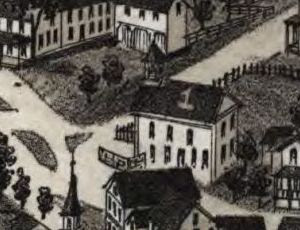
4. White's Hotel - W. R. White

Opened around 1882, William Roland White's hotel was virtually brand-new when Burleigh's map was created in 1885. Illustrated then in its 19th century location at the intersection of Depot and River Streets, today the building presides over the corner of Chester's Main and Riverfront Streets. Never physically moved, the former hotel's new address comes courtesy of a renaming of streets. The structure has been physically altered, though, with the later addition of a second-floor porch among other changes. Here are links to a couple of postcards of the hotel when it was known as the Riverside Inn from the late Shirley Bruso's excellent collection of Jacob's Ladder images:

http://homepages.rootsweb.ancestry.com/~shirleyb/jacobsladder/riverside2.html

http://homepages.rootsweb.ancestry.com/~shirleyb/jacobsladder/hotel2.html

This photograph, snapped by Francis Seddon in 2003, shows the Italianate-style beauty as it enters the 21st century:

http://homepages.rootsweb.ancestry.com/~shirleyb/jacobsladder/seddonhotel.html


5. Chester House - W. H. Day

Within fifteen years of being drawn into map image immortality, William H. Day's Chester House, on the corner of Main Street and Middlefield Road, was razed to make way for a new school. Isaac Stevens was the first proprietor of the tavern, opening the doors to travelers in the early 1800s. The two and a half story, red-brick Chester Grammar School, which replaced Day's inn, has been a prominent landmark as one enters town since the dawn of the 20th century.


6. Hampden Emery Co. (Upper Mill)

The industrial abrasive, emery, was first detected after a visit to Chester on August 19, 1863, by Professor Charles T. Jackson, a Boston geologist who had been poking around for mineral samples in a mine owned by the Chester Iron Company. The mine had been worked unsuccessfully for a short span in the late 1850s after Dr. Heman S. Lucas's 1856 discovery of quantities of iron ore there and had restarted ore-extraction operations not long before Jackson revealed his findings to Lucas. Lucas confirmed the emery deposit several weeks later, the first major vein recorded in the United States.

Here's a link to a great article on Dr. Heman S. Lucas and the Chester emery trade by historian John Garvey, published in the May, 2006, newsletter of the Chester Historical Society:

http://www.chestermass.com/Chester_Historical_Society/Newsletter/2006_May.pdf

And here's a link to an 1865 article in Volume 89 of the American Journal of Science by Professor Jackson, describing the discovery of emery in Chester in his own words:

http://books.google.com/books?id=o_cQAAAAIAAJ&dq=charles%20jackson&pg=PA87#v=onepage&q=charles%20jackson&f=false


Hampden Upper Mill

It is a sign of the times that in 1885, mills and industrial enterprises - complete with belching smokestacks - would be featured as map insets. Development and progress were admired and encouraged in the late 19th century, the American dream being reshaped and reformulated in a nation transformed by upheaval, content to look forward (indeed, driven to) lest the bloody past of a country divided overtake a prosperous future.


6. Hampden Emery Co. (Lower Mill)

The 1863 discovery of emery in Chester brought its own form of abrasive personal and commercial upheavals. The Chester Iron Company was quickly reorganized as the Chester Emery Company, the principals being Dr. Heman S. Lucas, Henry D. Wilcox, James T. Ames and John E. Lucas, Heman's brother. Trying to squeeze iron out of rock was soon forgotten as profitability in the emery trade ensued. No longer dependent on importation of emery from Turkey or Greece, companies nationwide contracted with the Hilltown firm to provide them with the mineral, resulting in the rapid growth of the Chester Emery Company within the first few years of its incorporation.

By 1868, James Ames was overseer of the emery company and the Chester mines - gaining the top spot per vote of the board of directors - and Dr. Heman Lucas was out. The Hampden Emery Company was formed in all due haste, with Dr. Lucas, Henry Wilcox and Professor Jackson at the helm. The industrial rivals slugged it out in court over the next several years, each asserting rights to the mines with the Chester Emery company ultimately emerging the winner of the six-year skirmish.

The mills of the Hampden Emery Company managed to stay open after the court decision using ore imported from Turkey. Dr. Lucas, seeking other sources of the mineral, purchased land in North Carolina where emery had been located and, shortly after, began mining operations there, securing a steady supply of the industrial necessity for his factories back home before a year had run out on the legal setback his firm had suffered. The 1883 death of his former partner and competitor James Ames brought the deeds to the Chester emery mines back into the hands of Dr. Heman Lucas and the Hampden Emery Company, the rights to the properties purchased by the firm soon after Ames's passing. Lucas himself passed away in 1900. Around 1913, the Chester emery mines were closed.


Hampden Lower Mill

Dr. Heman Lucas's travails weren't limited to acts of man. The New York Times reported on July 14, 1874, that flooding in Chester had resulted in $10,000 worth of damage to one of the mills of the Hampden Emery Company. The Hannum Edge Tool Company - another concern of Lucas's - also sustained damage during the leveling display of nature's wrath. Many farms (including Lucas's fifty-acres) were affected by the raging waters, so powerful that Chester buildings were moved from their foundations and spun, left facing compass points anew. Four bridges were swept away and many roads were washed out in the deluge, which affected just about every resident in town. 1874 was a bad year for floods in Western Massachusetts, the Williamsburg reservoir dam on the Mill River in neighboring Hampshire County bursting under heavy rainfall two months earlier, on May 16, 1874, resulting in a loss of 139 downstream souls.

Here's a link to a previous EWM map post detailing an 1854 map of Hampshire County which, oddly enough, includes Chester Village although Chester had become part of Hampden County when that county was created from Hampshire County acreage on February 25, 1812:

http://explorewmass.blogspot.com/2009/07/map-hampshire-county-massachusetts-1854.html


7. Grant Corundum Wheel Co.

According to the Report of the Tax Commissioner of the Commonwealth of Massachusetts, published in 1889, grinding wheel manufacturer Grant Corundum Wheel Company, was certified an organization on November 14, 1882. Company owner Frank Grant's business, which had relocated to Chester around 1880 from Manchester, NH, was somewhat and unfortunately short-lived, burning to the ground in 1892.


8. Chester Granite Works

Although it had to be hauled into town over three miles along the Chester & Becket Railroad from where it was quarried in Becket to be worked, the blue-hued granite of Becket became known as "Chester dark" and "Chester light" to geologists, a sample's classification determined by the amount of black mica tinging the stone. In 1885, granite quarrying, cutting and polishing was growing into an important industry in Chester, the fine-grained stone highly desirable for its monument-quality texture. Today, one can visit the Chester-Hudson Quarry at Becket and step back into the past, thanks to the hard work and dedication of the folks at the Becket Land Trust and those who contribute to their awesome endeavors. Here's a link for more information:

http://www.becketlandtrust.org/quarry/index.htm


9. James Keefe's Quartz Mill

Perched on the edge of Walker Brook, right upstream from where the West Branch of the Westfield River runs into it on the way to meet her two sister branches, Keefe's Quartz Mill was just one of several commercial concerns owned by the Keefe family of Chester. Quartz exists in abundance in the area, and when ground, finds its profitability in its use in the production of porcelain. James Keefe served with the 46th Massachusetts regiment during the Civil War, one of many Chester men who fought for the Union.


10. Chester Tannery

In 1885, tanning - making leather from animal skins - was the primary industry in Chester, the tannery along Walker Brook one of three processors in town. According to the 1982 Massachusetts Historical Commission's Reconnaissance Survey Town Report for Chester, thirty-percent of Hampden County's 1885 leather production originated from Chester tanneries. Here's a link to the Commission's Report:

http://www.sec.state.ma.us/MHC/mhcpdf/townreports/CT-Valley/cht.pdf


11. Chester Grist Mill

A grist mill was a vital part of every town before the days of packaged bread and preservatives. Chester Grist Mill harnessed the hydro-power of Walker Brook to grind grain to flour. The seasonal Bisbee Mill Museum in nearby Chesterfield (66 East St.) offers visitors a chance to see a refurbished early-1800s grist mill. The museum is open Sundays 2-5, from June to October. Here's some more information, courtesy of the Jacob's Ladder Business Association:

http://www.jlba.org/Tourism/bisbee_mill.html


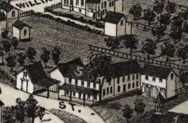
12 McGeoch & Co.'s Bedstead Factory

Surrounded by heavily wooded forest and graced with a strong flow of running water, Chester visionaries and entrepreneurs took advantage of the opportunities afforded them, sawmills and comb factories, bedstead, bobbin, crib and furniture makers springing up along river and stream banks, water wheels churning out the future.


13. Smith's Carriage and Sleigh Manufactory

Smith is a surname long-associated with the Town of Chester. In the 1911 New England Historic Genealogical Society reference work, Vital Records of Chester, Massachusetts, to the Year 1850, there are over five pages of Smith births, three pages of marriages and a bit more than two pages of deaths.


7. Grant Corundum Wheel Co.
14. T. Keefe's Bedstead Factory

Timothy Keefe was an active citizen in Chester trade and civic affairs. In addition to owning the bedstead factory on Middlefield Road, Keefe was proprietor of a general store, which he later handed down to his son, James, owner of the Quartz Mill on Walker Brook. The store had initially been opened by partners William Shepard and Hiram Barber in the village of Chester Factories in the early 1800s . Timothy Keefe was town clerk from 1863 to 1871, and was also important to the village's public library, serving as trustee.

By 1904, Keefe's Bedstead Factory and the remnants of Grant Corundum Company had been replaced by the brand-new facilities of the Hamilton Emery Company, under the direction of company founder, Frank Hamilton. Here's a link to the Chester Historical Society's feature article commemorating the firm's 100th anniversary in the society's, March, 2005, newsletter:

http://www.chestermass.com/Chester_Historical_Society/Newsletter/2005_March.pdf


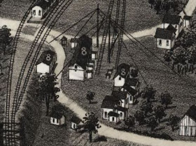
15. B. & A. Round House

On May 15, 1833, the Western Railroad Corporation was established and charged with extending the Boston & Worcester Railroad to Massachusetts' western border. In October of 1839 the first train arrived in Springfield from Worcester. By May 24, 1841, trains were running as far west as Chester Factories, bringing a new avenue of prosperity to the village. As the massive rail transportation project moved toward the New York border, Chester's importance grew to the line, becoming a certain stop so that pusher locomotives could be added to passing trains in order to assist them in surmounting the unforgiving grades around Gobble Mountain and Walnut Hill and westward to Washington and beyond. The workhorses of the Western railroad were stored in the round house, with a turntable guiding them into their respective resting places. The Western Railroad had been renamed the Boston & Albany Railroad by the time L. R. Burleigh's map was produced in 1885. A view from Google Earth shows the dirt circle tracing of the turntable and remnants of the round house still in place.


16. B. & A. R. R. Station

The Boston & Albany Railroad Station in Chester, though never reborn with the grand architecture of others along the line, was a welcome sight before the days of dining cars, many a hungry wayfarer disembarking an ever-swaying carriage into the warm glow of the eatery located there while the yardmen went about the business of coal and water amidst the pulses of steam and the clanging of bells, the explosive clash of locomotives connecting for the climb ahead purposeful and true. Today the station is lovingly maintained by the Chester Foundation and is open for visits seasonally, by appointment or during special events. For some incredible photographs and history and more information about making a trip out to the tracks, visit the Chester Railway Station web site:

http://www.chesterrailwaystation.org/


17. Post Office

One can read books, scan reports and peruse old newspaper articles for weeks and still never know as much about a town as you would if you were a fly perched on the wall of the local Post Office for the day.


18. Skating Rink

After all of the granite-quarrying and emery-bonding and shepherding and leather-making. After all of the grain was milled and bedsteads were made and tables were waited. After the stores closed and the quartz was ground, the good folks of Chester were able to unwind at the skating rink, to strap wheels to their soles and roll away the night in spinning social circles of small town Western Massachusetts. One can't help but feel that the people who sprung from and worked this hard, rocky soil deserved every moment of joy they could find in 1885.

As always, thanks for stopping by and take care.

* * *

For more maps - modern and historic - visit the EWM page, Trails, Rails & Roads: Western Mass. Maps. For best results viewing the above map and others at EWM, save images and view in a photo program with a zoom feature.


Map Source: Library of Congress; American Memory; Map Collections; Troy, N.Y.: L.R. Burleigh, [1885] (Milwaukee, Wis. : Beck & Pauli, litho); Digital ID: g3764c pm010820 http://hdl.loc.gov/loc.gmd/g3764c.pm010820


Home|Welcome|Table of Contents|Explore|Upcoming Events|Patrons|Marketplace|Contact|Privacy